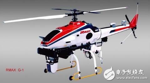
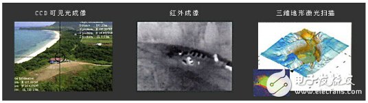
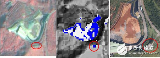
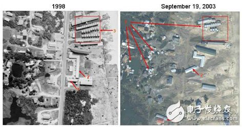
Unmanned aerial vehicle remote sensing (UnmannedAerialVehicleRemoteSensing), is the use of advanced unmanned aerial vehicle technology, remote sensing sensor technology, telemetry and remote control technology, communication technology, GPS differential positioning technology and remote sensing application technology, with automation, intelligence, specialization to quickly acquire land, Resources, environment and other spatial remote sensing information, complete the application technology of remote sensing data processing, modeling and application analysis. Unmanned aerial vehicle remote sensing system has become a hot topic for research in various countries in the world due to its advantages of mobility, speed and economy. It has gradually developed from research and development to the practical application stage, and has become one of the main aviation remote sensing technologies in the future. UAVs are unmanned aerial vehicles that are controlled by radio remote control equipment or on-board computer program control systems. The unmanned aerial vehicle has a simple structure and low cost of use. It can not only perform tasks performed by manned aircraft, but also be suitable for tasks that are unsuitable for manned aircraft, such as geological disaster investigation in dangerous areas, air rescue command and environmental remote sensing monitoring. According to the system composition and flight characteristics, UAVs can be divided into two categories: fixed-wing UAVs and unmanned helicopters. Figure 1 Fixed-wing UAV Fixed-wing UAVs take off and land and fly through the gliding of the power system and the wings. Remote control and program-controlled flights are easy to achieve. The wind resistance is also relatively strong. There are many types and can carry multiple remote sensing sensors at the same time. Takeoff methods include taxiing, catapulting, vehicle-mounted, rocket boosting, and aircraft launching; landing methods are taxiing, parachute landing, and net collision. The landing of fixed-wing UAV requires a relatively empty site, which is more suitable for mining resource monitoring, forestry and pasture monitoring, marine environment monitoring, pollution source and diffusion situation monitoring, land use monitoring, and water conservancy, electricity and other fields of application. The technical advantage of the unmanned helicopter is that it can take off and land at a fixed point, and the requirements for the take-off and landing sites are not high. Its flight is also controlled by radio remote control or by on-board computer. However, the structure of unmanned helicopters is relatively complicated, and the control difficulty is also relatively large, so the types are limited. They are mainly used in the investigation of emergencies, such as single landslide survey, volcanic environment monitoring and other fields. Figure 2 Unmanned helicopter Remote sensing sensors are based on different types of remote sensing tasks, using corresponding airborne remote sensing equipment, such as high-resolution CCD digital cameras, light optical cameras, multi-spectral imagers, infrared scanners, laser scanners, magnetometers, synthetic aperture radars Wait. The remote sensing sensor used should have the characteristics of digitization, light weight, high accuracy, large storage capacity, and excellent performance. Figure 3 Acquire multiple remote sensing images Post-processing technology of remote sensing data At present, most UAV remote sensing systems use small digital cameras (or scanners) as airborne remote sensing equipment. Compared with traditional aerial photographs, there are many problems such as larger image size and more images. For the characteristics of remote sensing images and cameras Calibration parameters, posture (or scan) posture data and relevant geometric models are used to geometrically and radiation correct the image, and corresponding software is developed for interactive processing. At the same time, there are automatic image recognition and rapid splicing software, which can realize the rapid inspection of image quality and flight quality and the rapid processing of data to meet the real-time and rapid technical requirements of the entire system. For further construction and analysis, use corresponding remote sensing image processing software. (1) The Space Information Research Center of the Faculty of Science, National Taiwan University uses drones to take low-altitude large-scale images, cooperate with the FORMOSAT2 classification for abnormal extraction, and interpret illegal waste deposits (solid waste, etc.) in Taoyuan County for environmental pollution and law enforcement investigations. Figure 4 FORMOSAT2 Figure 5 Classification results Figure 6 UAV image (2) Nicolas Lewyckyj and others in the United States use UAV-RS The technology conducts natural disaster surveys in North Carolina, and accurately assesses the losses of houses and villages through orthophoto processing and analysis. It shows the quick response capability of UAV remote sensing technology, which provides timely and accurate data for disaster management. Figure 7 Pre-disaster pictures Figure 8 Post-disaster pictures
ZGAR Aurora 3000 Puffs
ZGAR electronic cigarette uses high-tech R&D, food grade disposable pod device and high-quality raw material. All package designs are Original IP. Our designer team is from Hong Kong. We have very high requirements for product quality, flavors taste and packaging design. The E-liquid is imported, materials are food grade, and assembly plant is medical-grade dust-free workshops.
Our products include disposable e-cigarettes, rechargeable e-cigarettes, rechargreable disposable vape pen, and various of flavors of cigarette cartridges. From 600puffs to 5000puffs, ZGAR bar Disposable offer high-tech R&D, E-cigarette improves battery capacity, We offer various of flavors and support customization. And printing designs can be customized. We have our own professional team and competitive quotations for any OEM or ODM works.
We supply OEM rechargeable disposable vape pen,OEM disposable electronic cigarette,ODM disposable vape pen,ODM disposable electronic cigarette,OEM/ODM vape pen e-cigarette,OEM/ODM atomizer device.
Aurora 3000 Puffs,Pod System Vape,Pos Systems Touch Screen,Empty Disposable Vape Pod System,3000Puffs Pod Vape System ZGAR INTERNATIONAL(HK)CO., LIMITED , https://www.zgarvape.com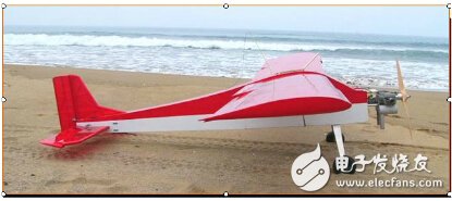

Comprehensive introduction to UAV remote sensing technology
1. Introduction to UAV remote sensing