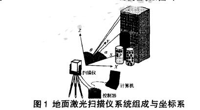
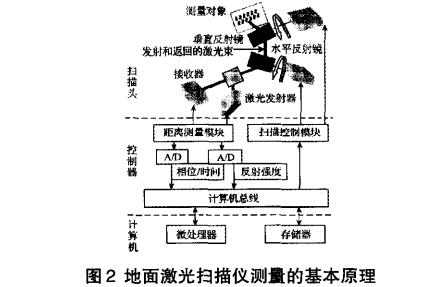
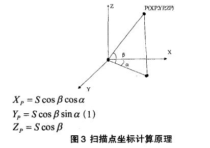
In recent years, with the continuous expansion of engineering measurement services and the requirements for measurement accuracy in three-dimensional design and manufacturing, traditional measuring instruments such as total stations and cross-section instruments have been unable to meet the needs of high-precision three-dimensional coordinate acquisition and "reverse engineering". . Compared with these traditional measurement techniques, 3D laser scanning technology has great technical advantages, especially in data acquisition, it is efficient, fast, accurate and simple, and is widely used in various fields. With the wide application of 3D laser scanners in the engineering field, this internationally developed high-tech has attracted the attention of researchers. This technology uses non-contact high-speed laser measurement to acquire geometric data and image data of terrain or complex objects. Finally, the post-processing software processes and analyzes the collected point cloud data and image data, and converts them into absolute coordinate system. The three-dimensional spatial position coordinates or the three-dimensional visualization model of complex and irregular scenes is both time-saving and labor-saving. At the same time, the point cloud can also output a variety of different data formats, as a data source for spatial databases and to meet the needs of different applications. . The entire system usually consists of the following four parts: 1) 3D laser scanner; 2) digital camera; 3) post-processing software 4) power supply and accessory equipment. Figure 1: According to the scanning platform, 3D laser scanners can be divided into: airborne (or on-board) laser scanning system, ground-based laser scanning system, and portable laser scanning system. As the most time-sensitive 3D data acquisition tool, 3D laser scanner can be classified as follows according to its effective scanning distance: (1) Short-range laser scanner: its longest scanning distance is less than 3m, and the best scanning distance is 0.6~1.2m. Usually, this type of scanner is suitable for small mold measurement. The scanning speed is fast and the precision is better. High, can be as many as 300,000 points, with an accuracy of 0.018mm. For example: Minolta's VIVID 910, handheld 3D data scanner FastScan, etc., belong to this category. (2) Medium-distance laser scanner: The longest scanning distance is less than 30m, which is mostly used for the measurement of large molds or indoor spaces. (3) Long-distance laser scanner: The scanning distance is more than 30m, which is mainly used for the measurement of buildings, mines, dams, large civil engineering, etc. For example: Austria's Rieg | company's LMS Z420i 3D laser scanner and Switzerland's Leica C10 laser scanner, etc., belong to this category. (4) Aeronautical laser scanners: The longest scanning distance is usually greater than 1 km, and an accurate navigation and positioning system is required, which can be used for scanning measurements of a wide range of terrain. The reason for this classification is that the effective distance of the laser measurement is an important condition for the application range of the 3D laser scanner, especially for the observation of large objects or scenes, or the inaccessible features, etc., must take into account the scanner Actual measurement distance. In addition, the farther the object is measured, the accuracy of the ground object observation is relatively poor. Therefore, to ensure the accuracy of the scanned data, it must be used within the standard range specified by the corresponding type of scanner. Regardless of the type of scanner, the construction principles are basically similar. The main configuration of the 3D laser scanner consists of a high-speed, precise laser rangefinder with a set of reflective prisms that direct the laser and scan at a uniform angular velocity. The laser range finder actively emits laser light and receives signals reflected by the surface of the natural object to perform ranging. For each scanning point, the slant distance from the station to the scanning point can be measured, and the horizontal and vertical angles of the scanning can be matched. The spatial relative coordinates of each scan point and the station are obtained. If the spatial coordinates of the station are known, the three-dimensional coordinates of each scan point can be determined. Taking the LeicaC10 as an example, the scanner scans in the vertical direction with a mirror, and the horizontal direction uses a servo motor to rotate the instrument to complete a horizontal 360-degree scan to acquire three-dimensional point cloud data. The working principle of the ground-type 3D laser scanning system (see Fig. 2): The 3D laser scanner emits a laser pulse signal, which is diffusely reflected on the surface of the object and then transmitted back to the receiver along almost the same path, and the target point can be calculated. P Distance from the scanner S, the control encoder simultaneously measures the horizontal scan angle observation a and the longitudinal scan angle observation B for each laser pulse. The 3D laser scanning measurement is generally a custom coordinate system of the instrument. The X axis is in the horizontal 3 drawing, the Y axis is perpendicular to the X axis in the lateral scanning plane, and the Z axis is perpendicular to the horizontal 3 drawing. The coordinate principle of obtaining the target point P is shown in Fig. 3. The biggest advantage of the dimensional laser scanner technology is that it can quickly describe the object to be measured, and can directly obtain high-precision 1-point cloud data without the need of a reflective prism. This makes efficient 3D modeling and virtual reproduction of the real world. Therefore, it has become one of the hotspots of current research, and has been widely used in the fields of digital protection of cultural relics, civil engineering, industrial measurement, natural disaster investigation, digital urban terrain visualization, and urban and rural planning. (1) Digital city area Large-scale urban restoration, urban model reconstruction, urban road measurement, pipeline planning, design planning, urban design change, digital urban management, public security monitoring, municipal management. (2) Surveying and mapping engineering field Dam and power station basic topographic survey, highway surveying and mapping, railway surveying and mapping, river mapping, bridge and building foundation surveying, tunnel inspection and deformation monitoring, dam deformation monitoring, tunnel underground engineering structure, measuring mine and volume calculation. (3) Structural measurement Bridge renovation and expansion project, bridge structure measurement, structure inspection, monitoring, geometric dimension measurement, spatial position conflict measurement, space area, volume measurement, 3D high fidelity modeling, offshore platform, measuring shipyard, power plant, chemical plant and other large industrial enterprises Measurement of internal equipment; piping, line measurement, various types of machinery manufacturing and installation. (4) Construction and monument measurement Measurement of fidelity, monuments (ancient buildings, statues, etc.) in the interior and exterior of buildings, protection of cultural relics, restoration of ancient buildings, preservation of data, and other monuments, site mapping, product imaging, on-site virtual models, on-site protective image recording . (5) Emergency service industry Anti-terrorism, land reconnaissance and attack mapping, surveillance, mobile reconnaissance, disaster estimation, traffic accident orthophoto, crime scene orthophoto, forest fire monitoring, landslide and debris flow warning, disaster warning and on-site monitoring, nuclear leakage monitoring. (6) Entertainment industry Designed for film products, design for film actors and scenes, development of 3D games, virtual museums, virtual tour guidance, artificial imaging, scene virtual, live virtual. Fiber Optic Splice Closure,Fiber Optic Splice Case,Fiber Splice Closures,Outdoor Fiber Optic Splice Closure Cixi Dani Plastic Products Co.,Ltd , https://www.dani-fiber-optic.com